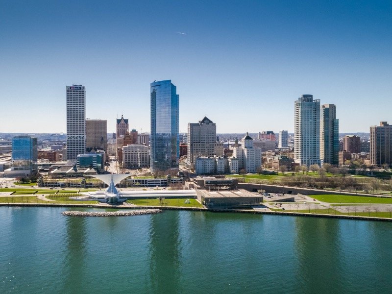

Before you read the headline, sarcastically point at the above photo of the lovely Milwaukee skyline and say, "Found it," some context.
Earlier this summer, OnMilwaukee hosted Milwaukee Downtown Week – it included a series of mini-food reviews profiling Downtown eateries where you could find lunch for under $7.
During an editorial meeting, I asked if Pleasant Kafe counted as Downtown. Half the room vehemently said yes; half the room vehemently cried no. Maps were projected onto screens, with arrows, paper and yarn pointing in all directions (mainly toward THERE IS NO CAROL). The words "circumference" and "radius" were used for the first time since high school geometry. We summoned random people walking past the meeting room – including our building manager – for their input and opinions – stealing precious minutes from their busy work days.
Six hours and one very unproductive Thursday later, we finally agreed to go our separate ways ... until one very annoying employee that definitely wasn't Matt Mueller brought it back up again this week.
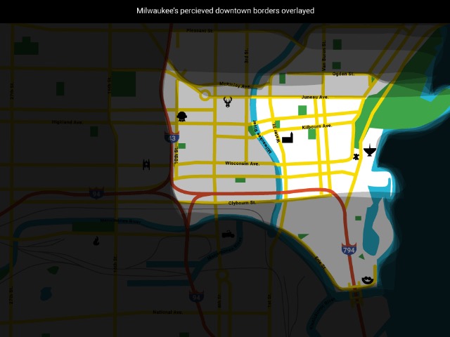
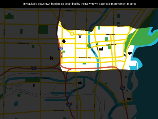
So there's only one obvious way to settle the debate: Look at the official Downtown borders as demarcated by Milwaukee Downtown, BID #21.
But that's no fun, so we decided to compare all of our respective "Downtowns" and see where you see the lines as well. So let's play *begins singing the Carmen Sandiego a cappella theme* 'Where In The World Are the Borders of Downtown Milwaukee.'
Jimmy Carlton
Sports editor

These are my Downtown borders: Lake Michigan to the east, the Milwaukee River to the west, Clybourn Street to the south and Ogden Street to the north. The lake and river are obvious natural borders; south of Clybourn is the Third Ward and north of Ogden is Brady Street/East Side, and I'm sure residents of both proud neighborhoods would adamantly tell you they were not part of Downtown.
Lori Fredrich
Senior writer, food & dining

If you ask me, Downtown is really a state of mind. It's the people, the urban buzz and everything that comprises the bustling center of our city. But, when it comes to borders, I tend to think of Downtown as the area between the lake and Marquette University, with a northern border that extends to right around Pleasant Street and a southern cut-off point at Erie Street, at the edge of the Third Ward.
Matt Mueller
Pop culture editor

When I was a kid growing up in the suburbs of Hales Corners, pretty much anywhere in Milwaukee was "Downtown." The lake? Downtown. Marquette? Downtown. Milwaukee County Stadium, then Miller Park? Sure, Downtown. If it was a big building more than two stories tall, it was Downtown.
Obviously my map's gotten more refined as I've grown up and gone to school, worked and lived Downtown, but I'm still probably more open with my borders than most. The lake clearly marks the border to the east, and Erie Street is your border to the south, which means you're roping in the Third Ward.
I stretch the western border to the freeway – not including Marquette – but then there's that tricky northern border. McKinley makes a nice demarcation line, but I'd then stretch it out to the intersection of Van Buren and where Water becomes Brady. Obviously no further – Brady Street is the East Side. Cut down to, say, Pleasant, and that's my Downtown. But there will always be a part of me that thinks of anywhere in the City of Milwaukee as "Downtown."
Jeff Sherman
Co-founder & president

We still own a home (condo) in Downtown, so it’s my neighborhood. Indeed Downtown is a neighborhood and it’s also an attitude — density, diversity and discovery. Greater Downtown Milwaukee extends into the Third Ward, Brady Street and even Pabst and Schlitz Park. But, you gotta define it with borders, and for the past 20-plus years, the Business Improvement District in Downtown has helped spearhead the positioning, growth and development of Downtown.
Here’s its borders that I also agree with: I-94 on the west, Lake Michigan and North Van Buren Street on the east, Schlitz Park and McKinley Street on the north, and the Menomonee River and West Clybourn Street on the south.
Molly Snyder
Senior Writer/Editorial Manager
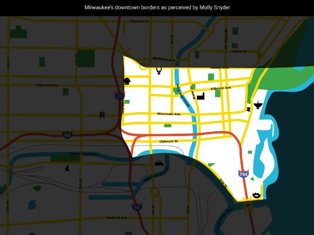
I believe Downtown borders Lake Michigan to the east, Erie Street to the south, 10th Street to the west and Juneau Avenue to the north.
Bobby Tanzilo
Senior Editor/Writer
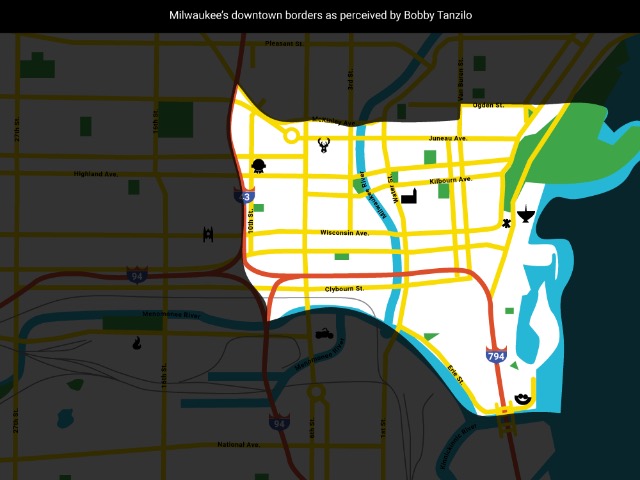
On three sides, I think the borders of what constitutes Downtown are pretty solid. The lake on the east, the river on the south and the freeway on the west. It's along the northern edge that it becomes iffy.
West of the river, I think McKinley is that line, because at least during my time here – in part thanks to the barrier created by the thankfully demolished Park East Freeway spur – Haymarket hasn't felt like the rest of Downtown. East of the river, I think the river, right where it bends, is the demarcation. But a little further east – past about Van Buren – I think the line is a little further south, at, say, Ogden, because anything north of that feels more like the lower East Side than Downtown.
Andy Tarnoff
Publisher
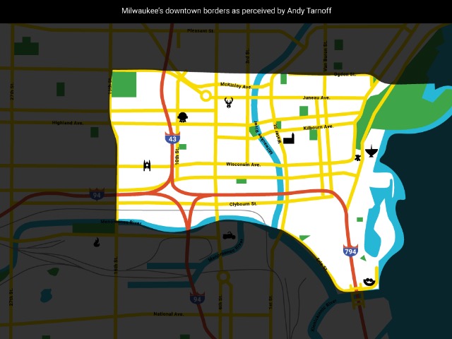
As far as I’m concerned, Downtown ends on the south at the Third Ward arch on Erie – I think the division of I-794 is a little too artificial. I’d cut it off on the north side at Ogden (Brady Street isn’t Downtown), and on the west side at the end of the Marquette campus. The east border is obvious, right?
Overall