


If you like this article, read more about Milwaukee-area history and architecture in the hundreds of other similar articles in the Urban Spelunking series here.
As lake levels reach new heights – in late August Lake Michigan was an inch above its record-high August monthly level, according the Army Corps of Engineers – beaches have been swallowed up while at the same time the lake has hurled onto the land evidence of the material that created that very land.
Much of the Milwaukee lakefront would be unrecognizable to 19th century residents because a large portion of the land has been claimed from the lake bed via landfill.
That landfill has come in the form of a wide variety of materials, including ash from factories, soil and stone from construction projects across the decades and materials from demolished buildings, too.

(PHOTO: Dave Wittemann/Old Milwaukee Facebook)
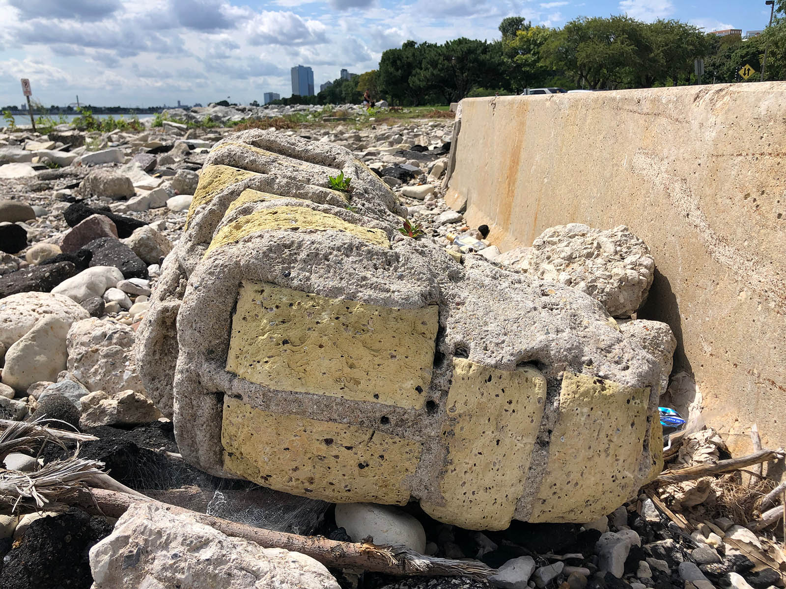
For years, folks have wondered about bits of architectural stone decoration, including parts of columns, capitals, sections of blacktop with painted lines, cream city bricks still attached with mortar and egg and dart-style trim, among other items mixed in with the fill.
These have been found along the water’s edge up in Shorewood and all the way down to the Northpoint refreshment stand parking lot, leading many to try and figure out from which demolished buildings these things came.

Further south, some of the McKinley Marina was created with landfill in the early 1960s and the current McKinley beach and playground were reclaimed in the late 1980s using stone from the deep tunnel project.
Recently, along the area north of Bradford Beach, which was once home to the gun club, my friend Jeff Bentoff discovered red brick street pavers bearing the marks of national companies like East Galesburg, Illinois-made Purington Block; Poston Pavers, from Crawfordsville, Indiana; and Canton, Ohio’s Metropolitan Block.
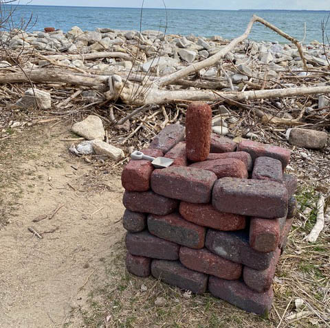
(PHOTOS: Jeff Bentoff)

These were presumably used as fill when brick-paved streets and alleys were replaced with more modern pavement. (Sometimes, blacktop was laid atop the pavers and time has eroded the top layer in spots around town exposing these bricks.
Landfill at the lakefront dates back to at least the 1870s when the Chicago and North Western Railroad, which owned much of the land down there sought to add to its holdings.
Some of the land upon with Summerfest now sits was created around that time, too (though much of it wasn't filled in until the 1920s).
Areas further north were not filled until later, as part of the project to create Lincoln Memorial Drive, in large part a legacy of Milwaukee's Socialists, including Mayors Emil Seidel and Dan Hoan and parks leader Charles Whitnall.

This 1896 map shows Lake Michigan lapping at the foot of the bluff south of North Avenue.
According to a 1929 edition of the Milwaukee Sentinel, the work began, "between Mason Street and McKinley Beach, filled over a period of years by hauling in ashes and earth from wherever it could be obtained."
In 1923, work began on the Lincoln Memorial Bridge, which was designed by architect Alfred C. Clas. A bit of the original bridge survives on the East Side.
According to architect Herbert Grassold, who worked for Clas, the latter, "was the architect of landscaping development for Lincoln Memorial Drive," and had "schemes ... for extending the drive to the south with either a tunnel below the river or an overhead bridge."
In 1927, the year after the bridge was finished, at a cost of $630,000, a one-mile stretch of Lincoln Memorial Drive to McKinley Beach was finished and opened to the public.
On Nov. 18 of that year, the Journal wrote, "The acquisition of the land to continue the Lincoln Memorial Drive into Lake Park has given Milwaukee a roadway that rivals the most picturesque in other city."
"In 1928 the lagoon and park development of this section was completed," the Sentinel article added. "During 1928, the park board also did rough work on the two-mile northward extension (of Lincoln Memorial Drive), after city officials and Clement C. Smith, and other public spirited property owners worked successfully in obtaining the necessary riparian grants."

Lincoln Memorial Drive seen from just south of Mason Street in 1930 in a J.B. Murdoch photo
(above) and from Juneau Park in 1953 (below). (PHOTOS: Wisconsin Historical Society.

That extension was made possible by a years-long negotiation with lakefront landowners that resulted in many of them donating a million dollars’ worth of lake frontage to the City of Milwaukee to allow for the construction of Lincoln Memorial Drive all the way up to Kenwood Boulevard (the two roads were connected in 1929).
The roll call of donors includes many well-known Milwaukee names, like Falk, Cudahy, Bartlett, Goodrich, Pabst and Ott.
On Feb. 14, 1928, the Journal reported the donation and added that the State of Wisconsin gave the city permission to develop land as far 1,500 out into the lake but that, for now, only 600 feet of landwill was to be created.
As you might expect, the donation came with strings.
The property owners’ conditions including things like preservation of the present sand beach, prohibition of any kind of dumping, reconstruction of fences between private and public lands, a ban on trucks and on parking (except for "sightseeing purposes"), lighting of the road and a ban on "noisy amusements."
Also, "airplanes cannot land there and bathers must not disport along its banks." However, "excess ground may be developed to tennis playing, children’s playgrounds and skating."
This gift allowed the road project to leap forward.

At the foot of the Lincoln Memorial Bridge, looking south. (PHOTO: OldMilwaukee.net)
By September (the month after the ashes of the recently deceased Socialist congressman and newspaperman Victor Berger were strewn along the drive) the park board had already issued contracts for the grading of the road though Lake Park, past the gun club on the lake side and up the 70-foot bank where the new Lincoln Memorial Drive would hook up with Kenwood, replacing a more rustic narrow, winding road up the slope.
On the east side of the road would be a sidewalk for pedestrians and on the west side there was a bridle path planned.
"With an unobstructed view of the lake to the east and a deep, wooded ravine on the west," wrote the Journal on Sept. 9, 1928, "this 1,400-foot section will be one of the prettiest drives in the city."
With winter behind, by May 19, 1929, the Journal could report, "Grading and placing of crushed stone on Lincoln Memorial Drive north of McKinley Park is now under way along the Bradford Beach bathing place. The temporary bathing pavilion has been raised and moved father toward the shore to make room for the drive. Breakwaters are being built at each end of the beach to aid in building out the shore.

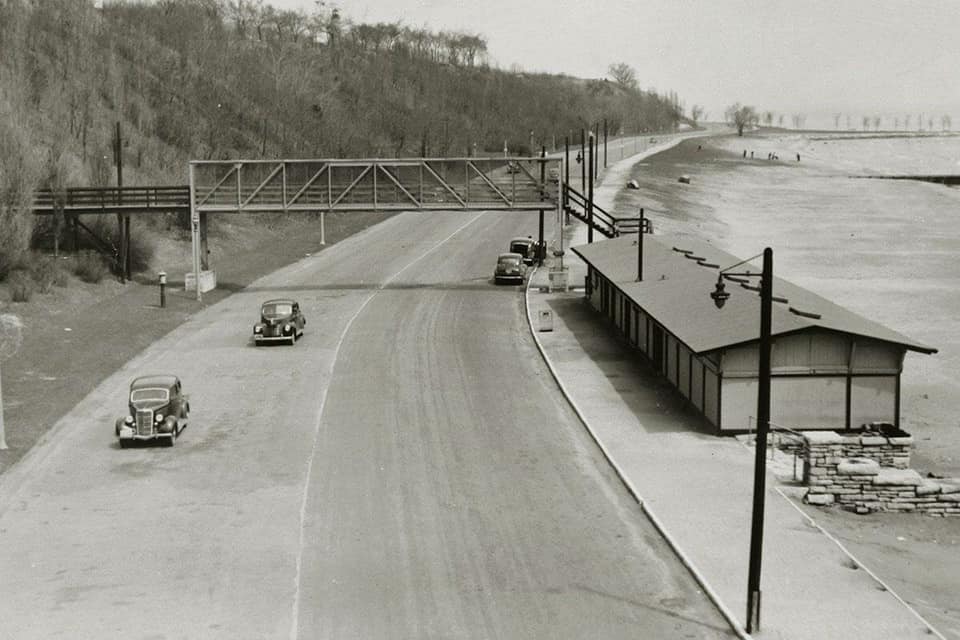
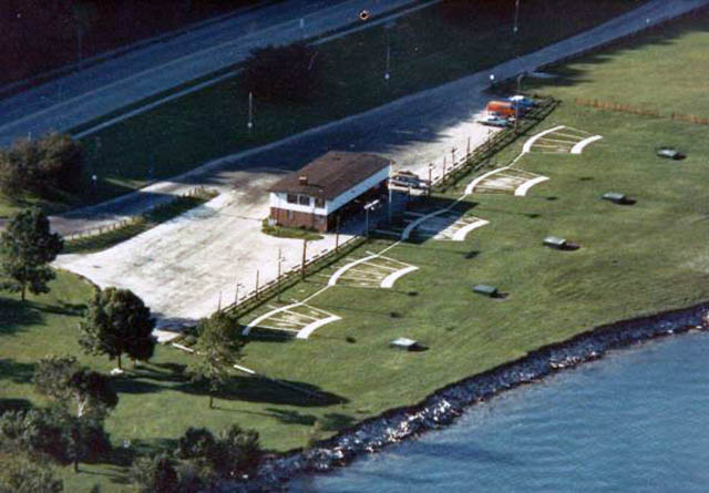
This July 1929 photo, looking north near the old Gun Club (at right) shows the "Shore Drive" before its completion and naming as Lincoln Memorial Drive. (PHOTO: Milwaukee Public Library)
"Work is also under way in finishing the grading at the north end of the drive in Lake Park. About 10,000 small locust trees have been planted on the bank along the drive south of Lake Park. The rope-like roots of the locust will hold the bank from washing. Later other trees, including evergreens, will be planted in with the locusts and in time the banks along the shore will resemble those of the ravine in the park, according to city forester O.W. Spidel."
That spring, bathers faced high lake levels that, like this year, were eating away at the beach. At the same time, Lincoln Memorial Drive construction was encroaching from the west.
But, by late September, the work was nearing completion along the three-mile extension of Lincoln Memorial Drive and a pedestrian bridge over the road was suggested to connect the beach with the Wahl Avenue stairway (at the foot of Bradford Avenue).
 Pedestrian bridge circa 1940s. (PHOTO: Jim Adair/Old Milwaukee Facebook)
Such a bridge was, in fact, built and, in 1951, replaced with the bridge that stands today a little further south, connected to the 1949 bathhouse.
The last stretch of Lincoln Memorial Drive officially opened on a rainy Saturday afternoon, Sept. 28, 1929, as city officials and a few dozen citizens watched Charlotte Kufalk, the 7-year-old daughter of park commissioner Max P. Kufalk cut a ribbon.
Although rain prevented Mayor Hoan and Ald. Cornelius Corcoran from speaking, there was talk of this being the start of a "super-highway," a long, smooth, beautiful lake shore highway for fast traffic from Michigan City, Indiana to Sheboygan or Manitowoc.
Stately trees, green parkland, sparkling lagoons, would line one side of this dream road, while the waves of Lake Michigan would lay ornamental revetments on the eastern side," boasted the Sentinel.
The completion was the realization of a long-discussed project. According to Lake Park Friends, when he designed Lake Park in the early 1890s, Frederick Law Olmsted envisioned a "Shore Drive" as part of the project.
As a reminder of how far back talk of this finally completed roadway went, Kufalk said the idea of "reclaiming submerged land for lake drive and park purposes originated with city officials in 1906," at which point the beach was created to help stem erosion and allow for the construction of an early version of the shore drive.
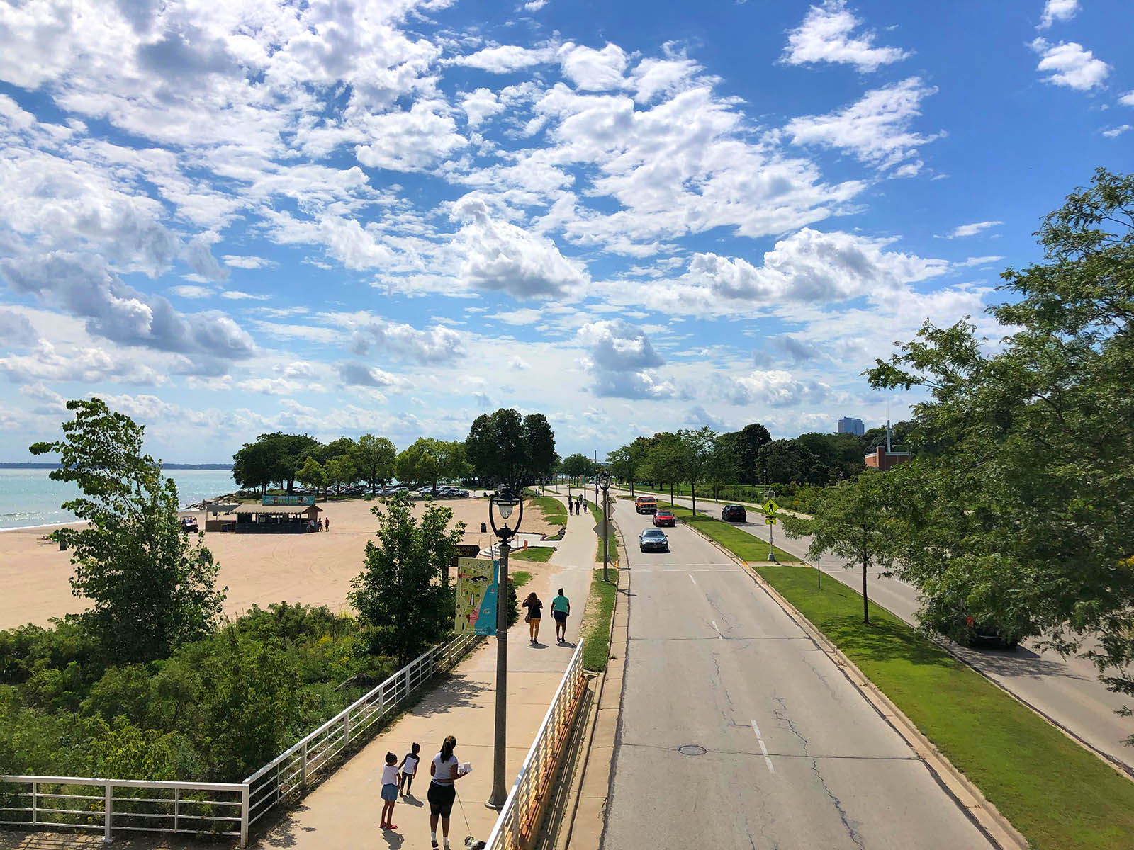
Looking south from the Bradford Beach pedestrian bridge today.
"Permission was obtained from the United States government to fill in to a point 1,500 feet from the original shoreline. About 80 acres have been reclaimed to date and plans for additional filling and park development are now being made."
After the ribbon was cut, "autos hasten(ed) to roll over (the) shore stretch," while the dignitaries retired to the Yacht Club for a luncheon.
In 1933, the state allowed the city to create a 54-acre landfill site upon which to build the Linnwood Water Treatment Plant and two years later, permission to fill even more land was passed by the state assembly, as long as the city ceded three acres to the state for a planned naval reserve armory building.
The gun club building (pictured below), at 2800 N. Lincoln Memorial Dr. It is now long gone.
(PHOTO: Wisconsin Historical Society)
The city transferred the lakefront land to Milwaukee County in 1936 when the city and county parks were merged into the current County Parks System.
Much of today’s Veterans Park was created from landfill beginning in 1957 using 2.5 million cubic yards of soil and stone from area freeway construction. More fill expanded the park during the 1970s, and of course there was the McKinley Beach fill in the ‘80s.
A new Lincoln Memorial Bridge was built in 1982.

The new bridge under construction in 1982. (PHOTO: Milwaukee Public Library)
Most recently, fill was used to create the 22-acre Lakeshore State Park just off the shore of the Henry Maier Festival Grounds. It officially opened in June 2007.
The current snack bar building – home to MooSa's – was built in 1960. An earlier drive-in food stand was located across the street in what is now a Bradford Beach parking lot.
Three years later, the current pumping station was built at the foot of Northpoint hill, replacing a more ornate earlier pumphouse.
The old Coast Guard Station, at 1600 N. Lincoln Memorial Dr., pre-dated the current road, having been built in 1915. It was razed and replaced with a picnic pavilion in 2008.
The Colectivo at the Lake opened in 2002 in the former flushing station, which also pre-dated Lincoln Memorial Drive, having been erected in 1888.
In 1999-2000, the northern stretch of Lincoln Memorial Drive was rebuilt and a median strip added.
Next time you’re at the lakefront, and especially walking, biking or driving along the beautiful Lincoln Memorial Drive, consider that you’re atop what barely a century ago was still lake bed, under water.
Walk over to the water's edge and you just might spy some of the interesting materials used to create the land upon which you're standing.
Born in Brooklyn, N.Y., where he lived until he was 17, Bobby received his BA-Mass Communications from UWM in 1989 and has lived in Walker's Point, Bay View, Enderis Park, South Milwaukee and on the East Side.
He has published three non-fiction books in Italy – including one about an event in Milwaukee history, which was published in the U.S. in autumn 2010. Four more books, all about Milwaukee, have been published by The History Press.
With his most recent band, The Yell Leaders, Bobby released four LPs and had a songs featured in episodes of TV's "Party of Five" and "Dawson's Creek," and films in Japan, South America and the U.S. The Yell Leaders were named the best unsigned band in their region by VH-1 as part of its Rock Across America 1998 Tour. Most recently, the band contributed tracks to a UK vinyl/CD tribute to the Redskins and collaborated on a track with Italian novelist Enrico Remmert.
He's produced three installments of the "OMCD" series of local music compilations for OnMilwaukee.com and in 2007 produced a CD of Italian music and poetry.
In 2005, he was awarded the City of Asti's (Italy) Journalism Prize for his work focusing on that area. He has also won awards from the Milwaukee Press Club.
He has be heard on 88Nine Radio Milwaukee talking about his "Urban Spelunking" series of stories, in that station's most popular podcast.


