

With gas prices on the rise and new policies and ideas on the table, it's time to look at how we get around. We all need to get someplace and we use many different modes of transportation to do so. As we kick off 2011 at OnMilwaukee.com, we're taking an in-depth look at how we get around with a special "Transportation Week," featuring all kinds of stories about how Milwaukee gets where it's going. So, buckle up, hop on and all aboard.
Milwaukee's current freeway system, at quick glance, looks like a neatly arranged system designed to get people and freight through and around the region.
However, the freeway system we know and are accustomed to today is a far cry from what was originally envisioned for the Milwaukee area when city planners -- who had no idea just how much of an impact the automobile would have on the population -- began devising a way to quickly and efficiently get people around the growing Milwaukee area.
What's left today is a small fraction of the system planners had in mind, with many stub ends and empty right of way corridors, a reminder of the intense and often heated battle pitting planners against neighborhood and community activists.
Milwaukee's freeway history can be broken down into four distinct eras, each encompassing the better part of a decade.
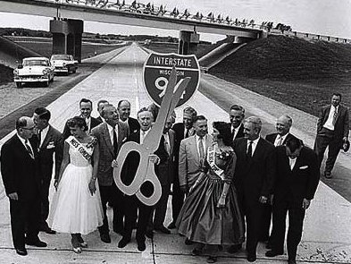
The 1950s: A glimpse of the future
Like most American cities, Milwaukee was booming in the post-World War II years. Returning GIs were starting families, buying and building homes further and further away from the traditional center of the city.
At the same time, the children of Milwaukee's first wave of immigrants were coming of age and, in the ear of prosperity, were looking to get out of their aging neighborhoods into bigger and better.
Milwaukee's existing roads weren't designed for the automobile. Most were laid out when horses and buggies were still the primary mode of transportation. The arrival of streetcars in the early 20th Century did little to help the situation. By the time cars became common, Milwaukee's roads were a mess of chaos and gridlock.
"They were very narrow," explains noted Milwaukee historian John Gurda. "Once the automobile came along, with mostly just one person in the car, you had a lot of gridlock."
Freeways, which allow motorists to zip across the growing metropolis in a matter of minutes, seemed the perfect and logical solution. The War had barely ended when, in 1946, the Common Council performed its first feasibility study and laid the groundwork for what would later become the area's transportation backbone.
"People thought it was manna from heaven," Gurda says. "They thought they were being delivered."
Of that original plan, two major routes still in use today were mapped out: the North-South and East-West Freeways, which presently carry I-94 into and through Downtown.
That was just the beginning. In 1948, voters approved a referendum to build a system of "express highways," and work commenced on the first segments in 1952.
More routes were added to the original plan, until a total of 13 freeways were proposed for the area. Only a handful were actually built to completion, namely the East-West and North-South.
In the beginning, Milwaukee's Common Council handling most of the freeway planning but as the system began to grow in size and beyond the city limits, the Milwaukee County Expressway Commission was formed in 1953.
Charged with the task of planning and purchasing right-of-way property, the commission released its first overall plan in 1955 which called for a $221 million project with an estimated completion date of 1972.
In addition to helping ease gridlock, the plan took into account the growing fears of a nation in the early years of the Cold War. According to the report, the long and straight routes of the major freeways would provide "fire breaks in the event of a bombing."
A year later, Congress approved the Interstate Highway Act. Wisconsin was given two Interstate routes, with I-94 passing through Milwaukee.
The 1960s: A growing system
By the end of the 1950s, freeway plans were stretching well beyond the city limits and it was necessary to include surrounding counties in the planning process.
In 1960, the Southeast Wisconsin Regional Planning Commission was established by state law to facilitate cooperation between Milwaukee, Waukesha, Racine, Kenosha, Ozaukee, Washington and Walworth Counties, 147 cities and towns within those counties, the state and federal government.
Quickly, the SEWRPC got involved with the process.
Serving in a supervisory capacity, the SEWRPC worked with the Expressway Commission and the State Highway Department (the precursor to the modern-day Department of Transportation).
"The Commission was formed as an advisory planning agency," says SWERPC Executive Director Ken Yunker. "(The Expressway Commission) did the enginnering, construction and operation of the freeways."
SEWRPC's first comprehensive study, completed in 1966, called for 16 freeway routes in the seven-county Southeastern Wisconsin area, though few of the routes were new additions to the original city and county master plans.
"There were certain freeways proposed that didn't exist in 1965 but some were planned facilities in previous plans," Yunker says.
In addition to the North-South, East-West, Airport and Zoo Freeways, six others were planned for the Milwaukee area, along with a route to carry U.S. 12 from Genoa City to the Rock Freeway/WIS 15 (which was upgraded to an Interstate in the 1980s.)
- Lake Freeway -- The Lake Freeway was to run from the Hoan Bridge south, through Bay View, South Milwaukee, Cudahy and Oak Creek into Racine and Kenosha Counties, eventually joining with a similar freeway in Illinois.
- Belt Freeway -- Designed to run along the far south and western edge of Milwaukee County from the Lake Freeway in Oak Creek to the current Holy Hill Road/WIS 167 interchange in southeast Washington County. There is a small trace of this proposed freeway still in existence; the Mequon Rd. overpass above U.S. 41/45.
- Stadium Freeway -- One of the best examples of Milwaukee's aborted freeway plan, the Stadium Freeway would have run from I-894 on the South Side north through West Milwaukee, past County Stadium and continuing north to a junction with the Bay Freeway just past Capitol Drive. Later planning proposed extending the route even further north, to WIS 60 in Cedarburg. In West Milwaukee, the freeway met strong opposition from residents and politicians, worried about losing homes and the industrial tax base. Much of the S. 43rd Street Corridor was cleared for an expressway that was never built. The northern stub of the Stadium Freeway was halted, too, and today is a 1.9-mile spur carrying U.S. 41 and ending at Lisbon Avenue. A Park & Ride lot exists today on the intended site of the Stadium Interchange's junction with I-894; MCTS buses use the ramps to access the lot.
- Bay Freeway -- The Bay would have run from the present-day junction of I-43 and WIS 57 in Ozaukee County and near the junction of WIS 16 and Capitol Drive in Pewaukee.
- Park Freeway -- The Park was to have formed the northern portion of the "Downtown Loop" enclosure. The western segment was to run between the Staduim Freeway and I-43, roughly along the route of Fond du Lac Avenue with a short spur running between Brown and Center Streets. East of I-43, the Park would have run a straight line to the Lakefront, before turning south along Lincoln Memorial Drive to the Hoan Bridge. Much of the land for this route was acquired and cleared but only a small stretch of the Park East was ever built.
- Fond du Lac Freeway – Another example of a route that was started, but never finished, the Fond du Lac Freeway was to run from the center of the city -- a junction of the Bay, Stadium and Park Freeways -- northeast along present-day Fond du Lac Avenue to the North Interchange on the northwest side.
The '60s were the high-water mark for freeway construction in Milwaukee, with roughly 10 miles of new freeway were completed every year. But those miles were coming at a significant cost -- not just to taxpayers. More than 6,000 homes were demolished, forcing 20,000 people to relocate in order to make way for freeways – many of which were never built.
As the decade grew to a close, freeway opposition began to grow. The Expressway Commission benefited from very liberal confiscatory power – a precursor to today's eminent domain -- and public opinion quickly shifted from the 1950s love-affair.
Freeway planning and construction left an obvious mark on the area, with large swaths of land carved out through some well-established and close-knit neighborhoods, many of which were sliced in half by ribbons of concrete.
An empty corridor ran along the southern portion of Fond du Lac Avenue, and east to the Lakefront, awaiting construction of the Park Freeways. In West Milwaukee, the South 43rd Street corridor was wiped out -- along with much of the suburb's industrial base -- in preperation for the Stadium Freeway.
West Milwaukee residents felt the brunt of freeway planning harder than most in the area as their taxes skyrocked with the loss of property tax revenue from businesses displaced by the planned freeway.
"The plan really hurt West Milwaukee," Gurda says. "Their taxes just popped."
Neighborhood resistance groups began organizing, especially in the Sherman Park and Bay View neighborhoods, where residents banded together to fight construction of the Park and Lake Freeways.
The Sherman Park group was especially strong, says Gurda, and it succeeded in stopping the Park West dead in its tracks. On the South Side, Bay View residents liked the idea of a Downtown connection, but weren't willing to lose more than 600 homes to make way for the planned freeway.
Numerous community hearings were held around the area and many of them grew heated. At Custer High School, one such meeting turned into an out-of-control shouting match between supporters and opponents. Picketers for both sides lined up outside at others and a hearing in Grafton was cancelled due to a bomb threat.
A 1974 referendum asked Milwaukee voters whether or not to construct five freeway segments:
- The Airport Spur (WIS 119)
- The Park West, from I-43 to a connection with the Stadium Freeway
- The Stadium South between County Stadium and I-894
- The Park East/Downtown Loop Closure between I-43 and I-794/Lake Interchange
- Lake Expressway between the Hoan Bridge and Layton Avenue.
Milwaukee County voters approved all five segments by wide margins, but of those, only the Airport Spur (WIS 119) was built, establishing a direct connection between the North-South Freeway (I-94) and Mitchell International Airport.
The rest were defeated by vocal neighborhood resistance groups, many of whom took their cases to the court system. Armed with a new weapon -- a federal law requiring all freeway plans to include an Environmental Impact Study -- gave freeway opponents greater resolve.
In 1975, County Executive John Doyne proposed completing another portion of the system, the so-called "Gap Closure Freeway" which would have linked the stub ends of the Stadium North and Fond du Lac Freeways.
That, too, never came to fruition and in 1979, state law abolished the Milwaukee County Expressway Commission, transferring its remaining obligations to the County Board.
In its final report, committee chairman Gordon King said that the board took "pride in the many accomplishments in bringing quality transportation facilities to Milwaukee County. but (regrets) the way the freeway system is left uncompleted with embarrassing 'stub ends.'"
Public opinion had swayed completely from the love affair of the 1950s, in large part because the freeway system already in place was already fulfilling its main promise of easing congestion on the city's streets.
"By the 1970s, when much of the current freeway system was already in place, traffic had moved from the surface arterials onto the freeway system," Yunker says. "The traffic had vanished; there was no congestion on the surface arterials and the freeways weren't gridlocked, either."
The 1990s and beyond: Aftermath
The scars of Milwaukee's freeway boom were still evident was the 20th Century came to an end. West Milwaukee finally started to see development along the abandoned Stadium Freeway corridor in the late 1990s, and today the corridor is home to a number of retail developments.
Downtown, the eastern corridor of the Park East Freeway underwent a makeover when construction began on the East Pointe Commons apartment complex in the '90s.
The western portion of the Park East corridor, on which the only portion of the freeway was ever built, became a target of then-Mayor John Norquist, who wanted the 0.8-mile spur demolished and the land opened for redevelopment.
The roadway was removed, beginning in 2002, replaced by an expanded McKinley Blvd., running between the Hillside Interchange and Water Street. The empty swath of land, however, upon which the Park East formed Downtown's northern boundary, still remains mostly vacant and undeveloped.
Over on the South Side, years of planning and arguments finally came to an end when construction of the Lake Parkway began in 1992, using the corridor originally intended for the Lake Freeway. The roadway opened in 1999, giving Bay View residents a direct and quick link to Downtown.
The roadway was not built to freeway standards -- something prohibited by state statutes. Though there are separated-grade interchanges, the Oklahoma Avenue intersection is at-grade and the 35 miles-per-hour speed limit is well below those found on the Interstate.
Currently, the Lake Parkway runs between the Hoan Bridge and Pennsylvania Ave., but there are plans in development for a possible extension which would stretch as far south as Racine County.
Today: Rebuilding and redesigning
The era of freeway building in Milwaukee is finished. Many proposed routes were completely wiped off the map by legislation, bringing the focus today on rebuilding existing routes.
The Marquette Interchange was rebuilt in the early 2000s, a complete overhaul of a structure designed in the 1960s. Such planning today, including left-hand ramps and short connectors, is considered a major design flaw, something that needs to be addressed in future planning.
The East-West Freeway is scheduled to undergo resurfacing over the next two years and a massive reconstruction of the North-South is already in progress.
All of these projects require extensive engineering as the area's freeway system reaches the end of its useful life.
"You can resurface a road two or three times but then you have to rebuilt it completely," Yunker says. "There are design flaws and new technologies that need to be addressed so the Commission has been making recommendations."
But there will be no further construction of new routes.
"No," Yunker says. "There are no discussions or plans for that."

